Sept. 24th

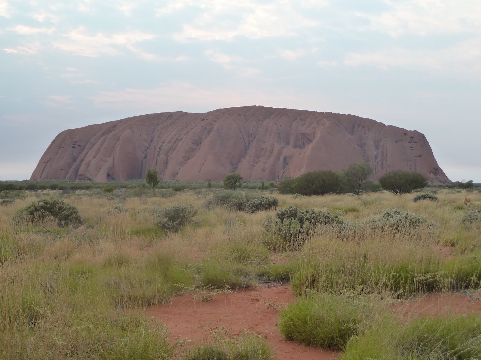
One of the things we’d read about Uluru was that you just had to witness it at sunrise. Apparently the color scheme on the rock was vastly different from the reds one is accustomed to during the day. Well, when I woke up, it was still incredibly dark out and I almost didn’t think to look at the clock. Luckily, I did, and I realized we’d better leave NOW if we were to have any chance of seeing this spectacle. We had another 180 km to go, and it wasn’t long before morning’s first glow was seen on the horizon. “C’mon! C’mon!” I kept thinking. Surely we can beat the sun! But it wasn’t looking very promising. Despite this, it turned out to be a cloudy day, and that worked in our favor. Every time the sun threatened to peak above the clouds, they would stay just one step ahead. By the time we were able to catch a glimpse of Uluru, the sun was just starting to show itself, and I was able to get some pictures of a very purple Ayers Rock. Talk about luck! Once we got through the gate, we found parking and decided to walk around the entire Rock.

Surrounded by flatland for as far as the eye can see, Uluru is an enormous beacon in the desert. One of the most recognizable symbols of Australia, Uluru stands 1,142 feet high, though it is thought that much more of it lies beneath the surface than is currently visible. It’s comprised of mostly sandstone and forms one continuous rock. Despite its monolithic appearance, when walking around Uluru, you can see many amazing faces and facets otherwise overlooked. We walked around the entire thing, taking in its many features as we went. We were not able to photograph a number of aspects out of respect for the sacredness of many areas. Many of the sacred stories about which this place has meaning are not shared with outsiders, and often they’re not even shared across gender lines. Although frowned upon for religious reasons, you can still climb to the top of Uluru on a very steep and occasionally deadly trail, but that was closed due to wind while we were there. Still, out of respect, it’s probably better we didn’t do it. They say the view from the top isn’t even that spectacular, when compared to the views from alongside it.

Our hike around the base took about two hours, and we admired all the faces of Uluru. We even came across a lovely spring that looked incredibly refreshing and was the reason for the peopling of the area. Uluru remains one of the only permanent sources of water in the region, thus bringing wildlife and man from far and wide. We also saw some rock art depicting ceremonies and animals and Dreamtime stories. Some natural formations looked like alien craft, and those were particularly sacred. It was a somber and fascinating place.
After our hike, we headed over to the visitor center which discussed a lot about the cultures of the region and talked about things like bush tucker (what the Aboriginal peoples ate before the arrival of colonists, the most interesting of which were witchety grubs and honey ants) and ceremonies. One thing that was not really covered was the geological aspect of the area, which we found odd since it was so unusual. Still, it was an interesting place.
Seventeen miles up the road was another unusual feature in the midst of a flat desert: Kata Tjuta. Also known as the Olgas, Kata Tjuta means “many heads” in the indigenous language. It is a series of 36 rocky domes, of similar composition to Uluru, and is also the source of many Dreamtime stories and a permanent source of water. It’s almost more interesting than Uluru. We were pressed for time, so we only did one of the two hikes up to the rocks and took in its beauty from a lookout point several miles away.

On our way out of the area, we made sure to stop for two geocaches in the red center. One was in the middle of the visitor’s village and the other was on an outlying road. Then we booked it back toward the Stuart Highway and headed back toward the north.
It’s always so interesting to drive along an area during the daylight hours after only having seen it in the dark. It seemed like we should have been surrounded by thick forests, but in reality, it was just the typical, scrubby outback we’d been seeing before. We’d see an occasional kangaroo, but nothing of too much note. Lots of hitchhikers, too, but we avoided those as well.

On our stretch north along the Stuart Highway, we decided to make one quick stop at the Henbury Meteor Crater site. Our car was pretty tiny, so I was a bit nervous about the 10 k drive on gravel out to the site. We were surrounded by cattle the entire way, and the last thing I wanted was to break down and have to walk through unpredictable bovines to get back to the main road. Luckily, we made it out there ok and finally parked the car. Upon arrival, we were greeted by a man who had a camper who told us the crater was about a half km out there. For some reason he made me uneasy, so I insisted we make this quick. We jogged out to the site, looked around, and came right back. It really didn’t look like much, but it was interesting to think about what the impact was like nonetheless. We ran back to the car, the man nowhere to be seen, and booked it out of there. We had a reservation at a motel in Alice Springs, and we had to really move if we wanted to get there by 8, when the lobby would close.

After a few hours of driving, we wound up in the outback town of Alice Springs. It seemed a little rough around the edges, but it also had a certain comfortable feeling about it, too. We navigated our way to the motel, but despite having about a half hour to spare, the gate to the lot was closed and locked. I called the front desk (thank goodness for that cell phone!) and they seemed confused as to why it would be shut already. They let us in, and we checked in. It was run by a nice retired couple from New Zealand (why they’d relocate from such a lush, lovely place to the wild west of Australia is a good question), and they answered some questions we had. For instance, they had a few strange gourd/melon things on their desk that we’d seen growing all along the Stuart Hwy. We thought they were probably poisonous, as the ones out in our Southwest are, but it turns out they were just melons and perfectly edible. Who knew? Upon asking about camel rides, they handed us a brochure on Pyndon Camel Tracks, a local camel outfitter whom I would call in the morning. We also asked about places to eat, and they warned us about wandering around at night. I guess it does get pretty rough after hours, hence the locked gate, but I also think a lot of the warnings may have stemmed from a rather racist attitude a lot of Australians harbor. Still, we weren’t going to push our luck, and we drove quickly down to the Red Rooster, an Aussie chain restaurant I’d remembered from my study abroad days, and got some chicken-based meals to go. We got back to our ensuite room and enjoyed the comforts that we weren’t afforded the last two nights sleeping in the car. It was just lovely!


No comments:
Post a Comment